
Wildfire risk for any US address
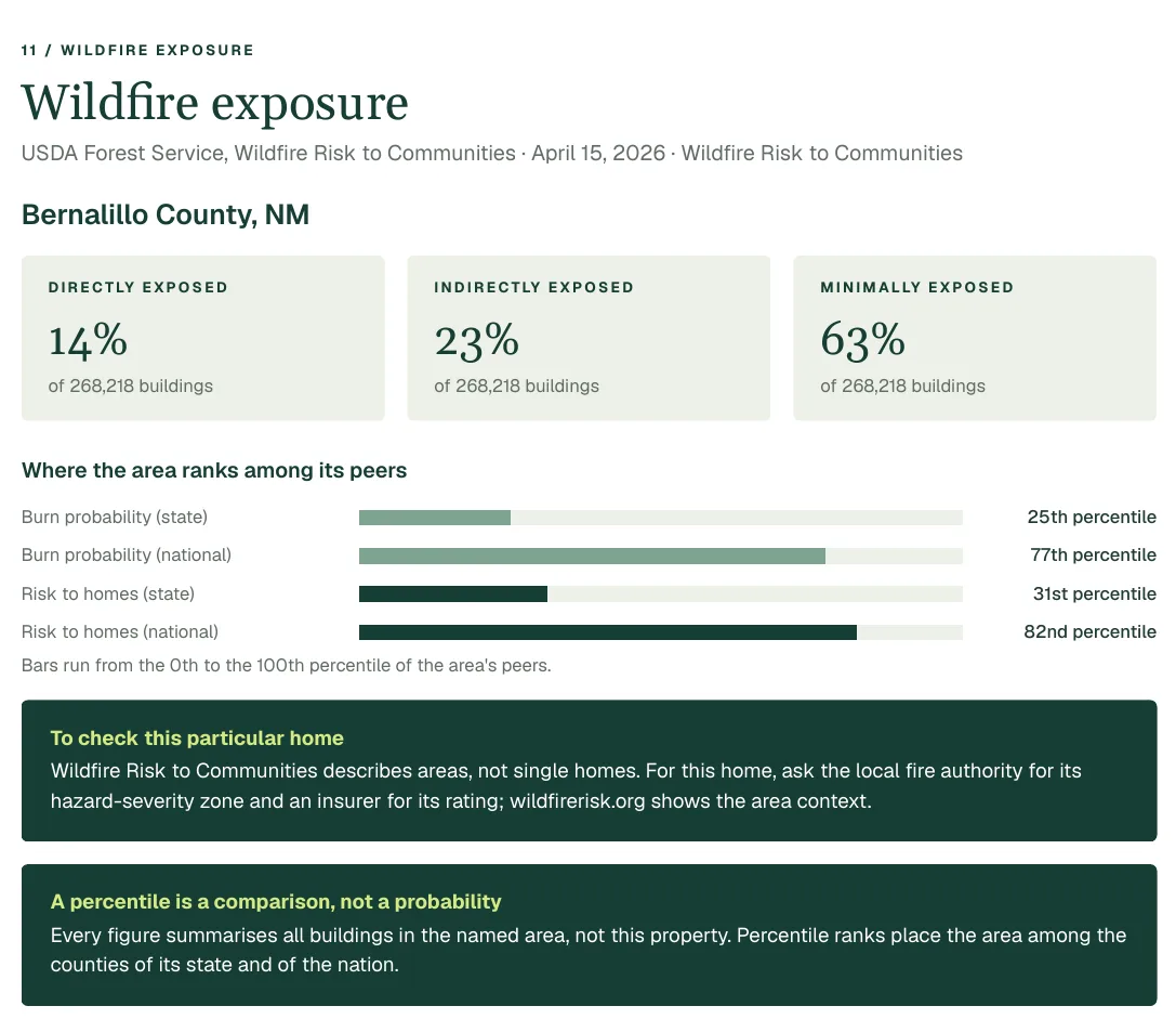
Wildfire reaches well beyond forest towns, and it now shapes insurance in many states. The Property Location Report shows how the county around an address ranks for wildfire and how many of its buildings are exposed, and the FEMA National Risk Index rates the census tract.
US addresses only. Every figure names its source.
Why it matters when you buy
It can change what insurance costs, or whether you get it
In several states insurers have raised prices or stopped renewing policies in high-risk areas. Seeing the wildfire picture before you buy gives you time to ask for a quote, not after you have signed.
Risk spreads further than the flames
Smoke, evacuation orders and road closures affect homes that never burn. A county's exposure tells you how common the conditions are around the property.
It is a county fact first
The USDA figures describe the county, not one lot. Treat them as the place's background, then ask local fire authorities about the property's own surroundings.
What the report shows
- The county's wildfire percentile against the other counties in its state, and against the country.
- The share of the county's buildings in areas the USDA classes as exposed to wildfire.
- The wildfire rating and percentile for the census tract in FEMA's National Risk Index, with its expected annual loss.
- The county's FEMA disaster declarations over the last 20 years, so a past fire shows up.
Source: USDA Forest Service, Wildfire Risk to Communities; FEMA, National Risk Index. The USDA figures are county summaries (the loaded release has no place-level polygons). The FEMA Risk Index is the December 2025 release, rated per census tract.
What it cannot tell you
- Percentiles are phrased 'of this county' or 'of the state's counties', never 'this home'. They say nothing about the roof, the lot or defensible space.
- A risk rating is the area's, ranked against its peers. It is not a probability for the property and not an insurance rating.
- A hazard that FEMA does not model is 'not applicable', not zero.
Before you buy
The report is a starting point. These are the questions it points you to.
- 1Does the county rank high for wildfire in its state?
- 2Is the home in a fire-prone setting: heavy vegetation, a single road out, steep slopes?
- 3Get a homeowner's insurance quote before you commit; ask whether the company writes new policies in the area.
- 4Ask the local fire authority about the property's recent fire history and any required clearance.
Questions
Can I check the wildfire risk for one address?
The Property Location Report gives the wildfire ranking of the county and the FEMA hazard rating of the census tract at that address. It is an area picture, not a rating of the individual building.
Where does the data come from?
From the USDA Forest Service's Wildfire Risk to Communities for the county, and from FEMA's National Risk Index for the census tract. Each figure in the report names its dataset and release.
Does a low ranking mean no risk?
No. It means the county ranks low against others in the dataset. The report never calls a place safe.
More in the same report
Flood zone
See the FEMA flood zone at a US address, how far the nearest Special Flood Hazard Area is, and what each zone means, on a map, from FEMA's National Flood Hazard Layer.
Superfund sites
EPA Superfund sites near a US address with their list status and boundary distance, plus leaking-underground-tank records and regulated facilities. Proximity is not contamination.
Crime
Offenses reported to the police agencies that cover a US address, from the FBI's Crime in the United States, with state rates for comparison. An agency's statistics, not a map of crime near a home.
Also: Flood zone, Crime, Superfund sites, Wetlands, Schools.