Learn how MapGO's Coastline Distance tool revolutionizes property analysis, risk assessment, and tourism planning with bulk CSV processing.
For professionals like real estate developers, environmental researchers, and travel planners, knowing the precise distance of a property or site to the nearest coastline isn't just a detail—it's mission-critical. Coastal proximity impacts property valuation, environmental risk assessments, tourism planning, and regulatory compliance. Manually calculating this data for hundreds or thousands of locations, however, is time-consuming, error-prone, and impractical. That's where Mapgo.io steps in, offering a seamless solution with its bulk CSV upload feature—and even more tools for developers via its API.
Why MapGO?
MapGO is a geospatial analytics platform that simplifies complex geographic calculations. Its standout feature? The ability to process hundreds of coordinates at once via CSV uploads, delivering accurate results in seconds.
For Developers and Integrators: Need real-time coastal proximity data in your app or workflow? MapGO's API is available via RapidAPI, enabling seamless integration into custom tools, dashboards, or automated systems.
Step-by-Step Guide to Bulk Coastal Proximity Analysis
1. Prepare Your CSV File
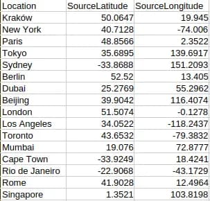
Create a spreadsheet with columns for Location (optional), SourceLatitude, and SourceLongitude (one row per property or site). The Location column can include names or identifiers for your coordinates, but it's optional—only SourceLatitude and SourceLongitude are required. Save the file as a CSV. No coding or advanced formatting is needed—MapGO accepts simple, clean files.
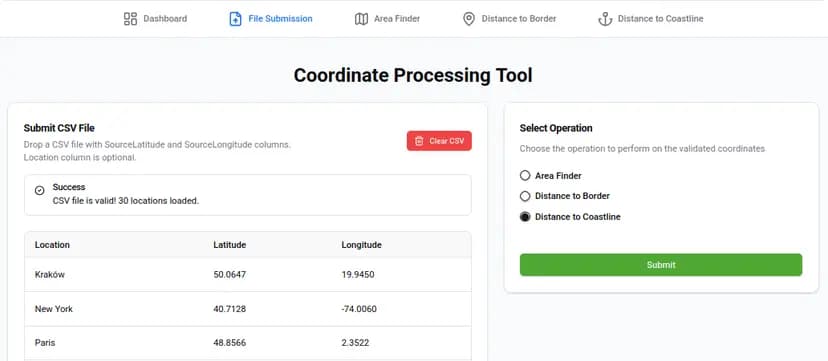
2. Upload and select the Distance to Coastline Operation
Log into MapGO, navigate to the "File Submission" page, and drag-and-drop your CSV. The file is sent to our system for processing. Once completed, the results will be available on the "Distance to Coastline" page, where you can view and manage your coastline distance calculations.
3. View and Export Results
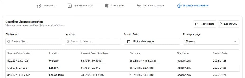
Once your file is processed, navigate to the "Distance to Coastline" page to view your results in a clear, interactive table. The table displays key details like Location, Closest Coastline Point, Distance, File Name, and Search Date. Use the search filters to quickly find specific locations or date ranges, and adjust the number of rows displayed per page for easier navigation. When ready, click the "Download CSV" button to export the results, including the newly added Distance column (in kilometers/miles). Use this data to filter properties by coastal proximity, assess flood risks, or plan travel routes with precision.
Real-World Applications
- Real Estate Developers: Quickly identify prime coastal properties for luxury developments and vacation homes. Calculate precise distances to highlight properties with ocean views or beachfront access.
- Tourism and Hospitality: Use coastline proximity data to market properties and plan itineraries. Create attractive vacation packages by identifying accommodations within specific beach distances.
- Insurance and Risk Management: Assess flood and storm surge risks for coastal properties. Determine premiums, evaluate claims, and identify high-risk zones.
- Urban Planning: Design coastal infrastructure like roads, ports, or seawalls. Make informed zoning decisions while minimizing coastal hazard risks.
Single vs. Bulk Uploads
While MapGO supports single-coordinate checks for quick queries, batch processing is where it shines. For example, a developer evaluating 200 potential sites could spend days manually plotting points on maps—or use MapGO to get results in minutes. Bulk uploads also reduce human error, ensuring consistency for audits or reports.
Future-Proof Your Workflows
MapGO is continuously evolving to meet user needs with upcoming features like expanded geographic datasets, advanced risk modeling, and AI-powered analytics.
Why This Matters
Coastal proximity data isn't just about convenience—it's about risk mitigation, cost savings, and strategic decision-making. A hotel chain avoiding flood-prone zones saves millions in insurance costs. A researcher tracking shoreline changes gains years of actionable insights. MapGO turns a tedious task into a competitive advantage—whether you're using its bulk CSV tool, API, or waiting for its next innovation.
Ready to streamline your coastal analysis?
MapGO makes it easy to calculate coastline distances for single or bulk coordinates—no subscriptions or coding required. Whether you're a real estate developer, travel planner, or logistics professional, our bulk CSV upload tool delivers precise results in seconds.
If you want to use bulk processing, you'll need a plan. MapGO offers lifetime access with no recurring fees—just a one-time payment for unlimited use. All plans include unlimited single coordinate lookups and depend on the plan, CSV data submissions. Prefer to start small? Our Free Tier offers 100 single checks per day—no credit card required.
Developers can also integrate real-time coastline data into their applications using our RapidAPI platform for seamless geospatial integration.