Discover how MapGO's Border Distance tool transforms cross-border operations with real-time calculations and bulk processing capabilities.
In today's globalized economy, businesses operating across borders face unique challenges—navigating customs regulations, optimizing supply chains, and ensuring timely deliveries. Understanding the precise distance to country or regional borders is crucial for efficient operations.
Why MapGO?
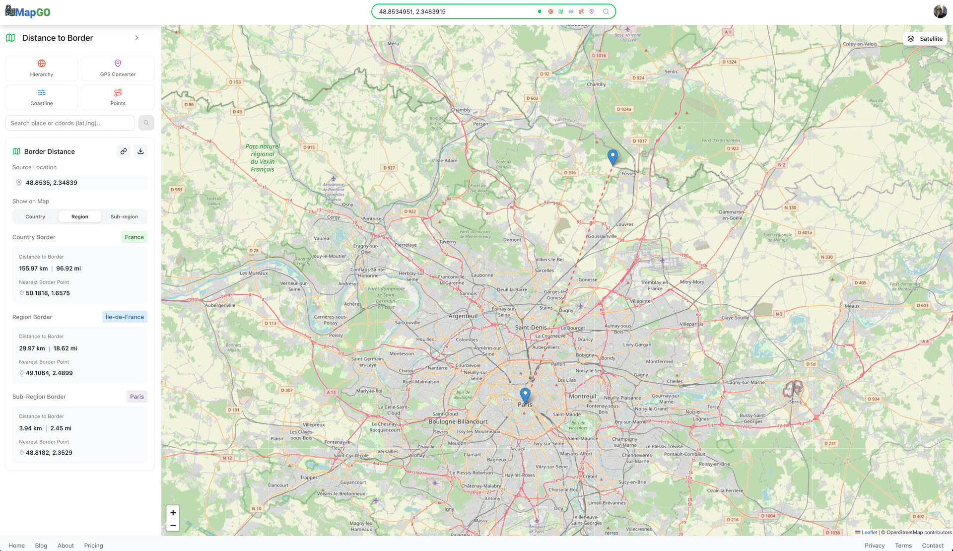
MapGO's Distance to Border feature allows businesses to measure the exact distance from any location to the nearest country, region, or sub-region border. With support for CSV uploads of up to 200 rows, you can process hundreds of coordinates in seconds—no coding required.
Why Straight-Line Distance?
- Speed and Scalability: Process hundreds of coordinates quickly for high-level planning and analysis
- Universal Application: Provides consistent measurements regardless of available road infrastructure
- Integration Ready: Use results as starting points for detailed route planning with routing APIs
Step-by-Step Guide to Bulk Distance to Border Analysis
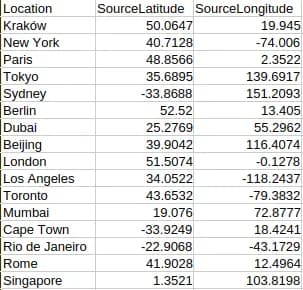
1. Prepare Your CSV File
Create a spreadsheet with columns for Location (optional), SourceLatitude, and SourceLongitude (one row per property or site). The Location column can include names or identifiers for your coordinates, but it's optional—only SourceLatitude and SourceLongitude are required. Save the file as a CSV. No coding or advanced formatting is needed—MapGO accepts simple, clean files.
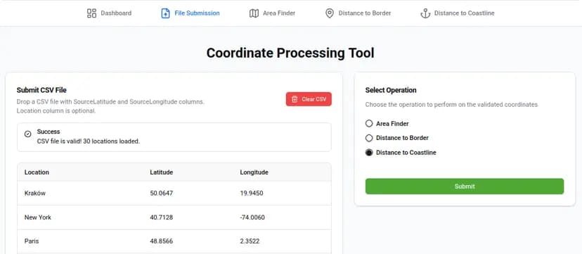
2. Upload and select the Distance to Border Operation
Log into MapGO, navigate to the "File Submission" page, and drag-and-drop your CSV. Choose Distance to Border from the list of operations. MapGO will analyze each coordinate and calculate its distance to the nearest country, region, or sub-region border.
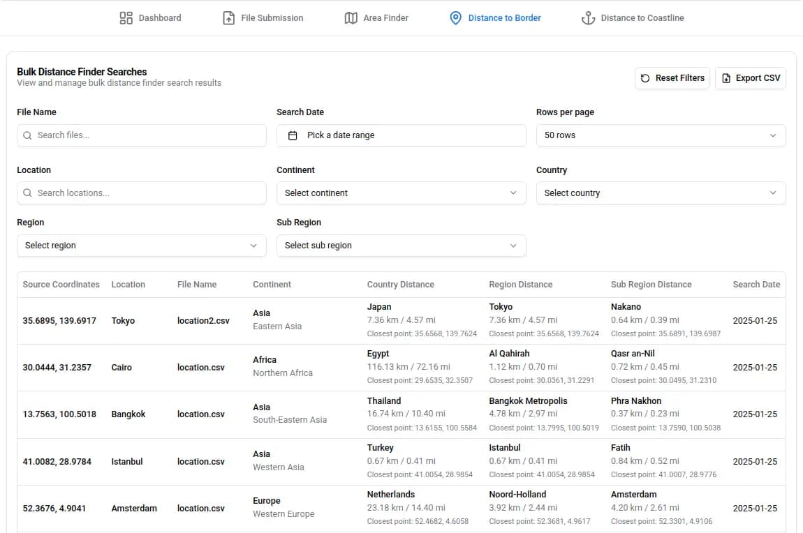
3. View and Export Results
Once processing is complete, view the results in an interactive table. Use filters to search by country, region, or distance range, and adjust the number of rows displayed per page. When ready, click the Download CSV button to export the data for further analysis.
Real-World Applications
- Logistics and Supply Chain: Optimize cross-border delivery routes by identifying shortest paths to customs checkpoints
- International Trade: Position warehouses and manufacturing facilities strategically near borders
- Travel and Tourism: Plan efficient cross-border itineraries with accurate distance calculations
Single vs. Bulk Uploads: When to Use Which
While MapGO supports single-coordinate checks for quick queries, bulk processing is ideal for large datasets. For example, a logistics company managing 200 delivery points could spend hours manually calculating border distances—or use MapGO to get results in under a minute. Bulk uploads also ensure consistency and accuracy, making them perfect for audits, reports, or strategic planning.
Why This Matters
Border distance data isn't just about convenience—it's about efficiency, cost savings, and strategic decision-making. A logistics company reducing transit times by even 10% can save thousands in fuel and labor costs. An international business optimizing warehouse locations can improve delivery times and customer satisfaction. MapGO turns a tedious task into a competitive advantage.
Ready to optimize your cross-border operations?
Visit MapGO to try the Distance to Border tool today. With support for CSV uploads of up to 200 rows (depending on your plan), you can process bulk coordinates effortlessly. Developers can also integrate real-time border distance data into their applications using the RapidAPI platform.